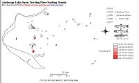
Stocking Density
800x600 1024x768
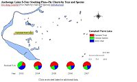
Pie Charts by Year and Species
800x600 1024x768
University of Alaska Anchorage GIS268, Spring 2003 Class Project
by Neil Moomey
|
Stocking Density 800x600 1024x768 |
Pie Charts by Year and Species 800x600 1024x768 |
|
Alaska has some of the best fishing in the U.S. however few Anchorage residents take advantage of the incredible fishing in their back yards. I created this project to help anglers locate the best fishing lakes in downtown Anchorage and as a visual planning tool for biologists and city planners. This project uses data from the Alaska Department of Fish & Game (ADF&G) 2003 Five-Year Stocking Plan. Eight lakes in downtown Anchorage are scheduled to be stocked from 2003 to 2007. Campbell Point Lake (Little Campbell Lake), Cheney Lake, DeLong Lake, Jewel Lake, Lake Otis, Sand Lake, Taku Campbell Lake (Taku Lake), and Chester Creek near University Lake (Behm Lake). Three species of fish are used, Rainbow Trout, Chinook (King) Salmon, and Arctic Char (Dolly Varden). Instructions: Select the resolution (800x600 or 1024x768) to best match your monitor size. The first chart represents the fish stocking density of these lakes by year and fish type. Click on the radio buttons to select the year and fish type. The legend will also show how many lakes fall in each category. Mouse over each lake to display it's name. Click on each lake to view a photo, map, and links to ADF&G data. The second chart represents the ratio of fish types to be stocked for each lake stocked by year. Mouse over each lake to view pie charts and the lake's name. Click on each lake to view a photo, map, and links to ADF&G data. I created the Anchorage map and data in ArcView 3.3 by modifying an existing shapefile provided by UAA. After modifying the polygon theme I created 16 new fields, one for each year and fish type plus one for the lake name and added stocking density data (Fish per Acre-Ft) computed from the ADF&G 2003 5-Year Stocking Plan. An Acre-Ft is an Acre of water one foot deep which I obtained from the ADF&G lake maps. The Acre-Ft for University lake was unavailable so I interpolated it based on nearby lakes of similar size. Next, I created MetaData for this new shapefile. I then created two Java 1.1 Applets using the Open Source Geotools library. I designed the Applets to be easily updated with new data. Because ArcView shapefiles are so large in filesize I was unable to include the themes (layers) of Anchorage roads and streams I created for this project and still have a usable website. A web page for each stocked lake was included with photos I took April 27-28, 2003 just after ice-out. If you are interested in Geotools you can download my entire project here. I'd like to thank Dan Bosch from ADF&G for his cooperation and advice. [Stocking Density] [Pie Charts by Year and Species] [MetaData] [Source Code] [Location Map] [Home] |